Carole Lombard Airplane Crash Location with on site visit, January 16, 1942.
12,410 View

- Publish Date:
- June 22, 2023
- Category:
- Pearl Harbor
- Video License
- Standard License
- Imported From:
- Youtube
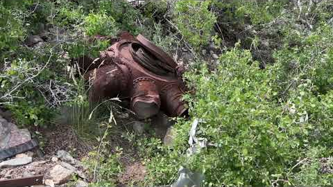
This video gives a brief explanation of the Carol Lombard plane crash that killed her and 21 others, with an onsite visit of the crash site.
Copy and paste the coordinates in Google Earth to visit the locations.
Point of Impact:
35.9510240, -115.4912924
Union Station Los Angeles:
34.0556340, -118.2363760
Indianapolis, Indiana Train Station:
39.7624566, -86.1602383
Indianapolis, Indiana Airport:
39.7170207, -86.2976916
St. Louis International Airport:
38.7475750, -90.3737455
Albuquerque International Airport:
35.0394211, -106.6085003
Boulder City Airport:
35.9487410, -114.8557577
Nellie Air Force Base:
36.2354122, -115.0342369
Venmo support.
https://account.venmo.com/u/ForrestHaggerty
PayPal support.
https://www.paypal.com/paypalme/forresthaggerty
Did you miss our previous article...
https://trendinginhawaii.com/pearl-harbor/the-stern-of-the-uss-arizona